


Flying an unmanned aerial vehicle (UAV) beyond visual line of sight has long been a benchmark of sorts for operators around the world. Having the expertise, experience and approvals to be able to do so significantly expands the services an operator is able to offer to their clients.
Asset inspection industry leader Geomatic Technologies (GT) has been working towards Beyond Visual Line of Sight (BVLOS) operation of UAVs recently, and in late 2016, the company undertook its first BVLOS test flight.
Flying a UAV BVLOS is currently only permitted in Australia with special approval from the Civil Aviation Safety Authority (CASA).
Approvals are granted on a case-by-case application and risk assessment. To date, only a handful of BVLOS flights have been undertaken in Australia, typically in remote areas away from people and infrastructure.
In the lead up to their inaugural test flight, GT worked closely and collaboratively with CASA to obtain the necessary permissions to undertake BVLOS flights over infrastructure easements in semi-urban areas.
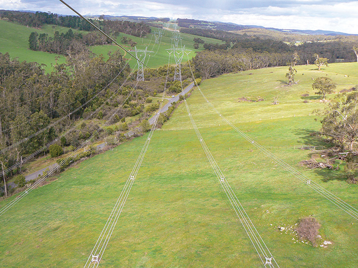
With an approved window of flight time and the Delair-Tech DT-18 fixed wing aircraft, fitted with a RGB camera, as their craft, the dedicated UAV team conducted four successful flights, covering approximately 80km, capturing down-facing imagery.
GT’s John Perkins, Chief UAV Controller said, “This is a milestone in our industry and we are extremely proud to be leaders in this emerging technology.
“Not only will our investment in BVLOS technology significantly expand our offerings in linear asset and easement inspections, it will also provide considerable operational savings and growth opportunities for our organisation.
“This is the first step in developing a deeper understanding of exactly what is possible with this technology, and what configuration is required to perform different types of inspections.”
The trials have taught GT valuable lessons about:
- Communication range and challenges
- Maximum bank angles and impact of lost imagery whilst banking
- Impact of wind and turbulence on imagery coverage
- Optimal flying height
- Speed and sustainability of the processed datasets for automated change detection and feature extraction
“These lessons will assist further trials that will utilise larger aircraft, carry payloads similar to our manned aircraft operations, and fit seamlessly into our established data processing, modelling and visualisation workflows,” said Gary Butcher, Innovation and Solutions Manager for GT.
The DT-18 aircraft used in GT’s trial was the first UAV system certified for BVLOS operations. The aircraft has good local support for training, servicing and maintenance; and it has a soon-to-be-released big brother (DT-26) which is capable of carrying an engineering grade LiDAR unit suitable for vegetation assessment and conductor modelling applications.
The future
There is an international push to develop BVLOS applications, given the extensive opportunities and benefits this technology provides.
There is a large investment in technology to enable the safe and efficient operation of UAVs whilst in parallel there is considerable work being done to define standards and regulations.
In the not too distant future UAVs will have collision avoidance sensors enabling them to detect other aircraft and take evasive action.
There will be standardisation of communication protocols and transponder technology so aircraft will be aware of other airspace users, and where required air traffic control can monitor and direct air traffic.
This will make it easier and quicker to fly BVLOS operations, enabling us to safely and efficiently utilise BVLOS UAVs for a wide range of aerial services. Geomatic Technologies want to be leaders in this emerging technology providing opportunities for operational savings and growth.
“We believe this technology will significantly improve the efficiency of our existing aerial services. Over time, it will also enable us to undertake more frequent data capture to support automated change detection and analytics, along with the ability to rapidly deploy aerial sensors across hard to access areas in the event of an emergency,” added Mr Butcher.
GT will continue working with CASA to gain approvals to utilise BVLOS UAV operations in situations where there is a clear benefit in utilising this technology.
This includes undertaking existing electricity network inspection services for AusNet Services, and offering a range of easement and linear infrastructure inspection services to utilities such as vegetation encroachment modelling and asset condition assessment.
 The program
One of the key strategic goals of the Geomatic Technologies UAV program is to develop the capability to fly camera and LiDAR equipped UAVs safely and autonomously over long distances.
This will allow operations such as aerial easement assessments and vegetation mapping to be performed safely with significantly reduced costs, and will allow for rapid mobilisation of responsive operations for AusNet Services and external customers.
At present, whilst the technology is available to perform BVLOS UAV operations, the process of getting the required approvals from CASA is based on a detailed site specific risk assessment, which takes time and resources.
Over the next few years, this will change and Geomatic Technologies wants to be a leader in this space, leveraging their core expertise in linear asset and easement inspections.
Flying a drone BVLOS is especially challenging as manned and unmanned aircraft need to learn to share the same airspace.
The risk of a drone colliding with a manned aircraft resulting in a crash is the primary risk that needs to be mitigated.
Applications for BVLOS flights have to demonstrate how these risks are mitigated and involve a detailed assessment of the airspace, airspace users, the local environment, local weather conditions, the aircraft and communication/telemetry performance.
This partner content is brought to you by Geomatic Technologies. For more information, please contact Paul Layzell, Manager Aerial Services at [email protected], or visit www.geomatic.com.au.